The Han River (Korean: 한강; RR: Hangang[e]) is a river located in the central region of the Korean Peninsula and is classified as a national first-class river in South Korea. The term "Miracle on the Han River," referring to South Korea's rapid economic growth, originates from this river.
The Han River has the highest flow rate of any river on the Korean Peninsula and also has the largest basin area. In terms of length, it is the fourth longest river on the entire peninsula and the second longest in South Korea after the Nakdong River.
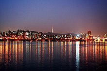
Seoul, the capital city of South Korea, is a rare example of a major metropolis with such a wide river running through it; few large cities are divided by a massive river approximately 1 kilometer wide.
The name Han River originates from the Korean word "Hangaram." In old Korean, "han" means "big" or "great," and "garam" refers to a river—so the name literally means "big river." Therefore, the Chinese character "Han" (漢) is merely a phonetic transcription and has no relation to China. Until the early Three Kingdoms period, the Han River was called "Daesu" (帶水). It is recorded as "Arisu"[7] (阿利水) on the Gwanggaeto Stele—an ancient stone monument erected in 414 AD. In the kingdom of Baekje, it was called "Ungniha"[8] (郁利河). The Samguk Sagi ("History of the Three Kingdoms"), a historical text, records the river as "Hansanha" (漢山河) or "Bukdok" (北瀆). The name "Han River" began to be used around the time when Baekje started interacting with China's Eastern Jin Dynasty; from then on, it was called "Hansu" (漢水) or "Hangang" (漢江).[9][10]
Arisu (阿利水) is an archaic term used to refer to both the Han River and the Amnok River (Yalu River). Because of this historical significance, today it is also used as the brand name for tap water sourced from the Han River in Seoul. The term seems to derive from "ari," meaning "big" or "great," combined with "su" (水), which means "water." Some also speculate that "ari" itself means "water."[11][12]
The origin of the name "Arisu" dates back to the Three Kingdoms period and is first mentioned on the Gwanggaeto Stele.
According to records from other states during the Three Kingdoms period, in Baekje it was called "Ungniha" or "Hansu," while in Silla it was referred to as "Wangbongha" or "Hansanha."[13] During the Goryeo Dynasty, it was called "Yeolsu." Thus, among the old names of the Han River, "Arisu" is the one most familiar to modern Koreans.
At one time, the Standard Korean Language Dictionary listed "Arisu" as a dialectal term for "deception," but due to insufficient data and lack of clear evidence, it was deleted.[14]
Baekje was founded in the basin of the Han River, and from the Three Kingdoms period onward, the zenith of each kingdom was determined by who controlled the middle and lower reaches of this river. Controlling the Han River was so crucial that it essentially defined a nation's golden age. This is commonly taught in schools when covering the Three Kingdoms period. Initially, Baekje held control, followed by Goguryeo, and later by Silla. As each kingdom rose to prominence, the other two would invariably form alliances to balance the power. This power dynamic continued throughout the entire Three Kingdoms period.
The importance of the Han River stemmed from its numerous advantages: the agricultural productivity of its basin, the securing of transportation routes through river navigation, and the establishment of maritime trade routes with China. It was the only region that could simultaneously connect major rivers flowing through the Korean Peninsula—such as the Taedong River, Geum River, Yeongsan River, and Nakdong River—and the shipping routes of the southwestern sea.
Unified Silla Period
After the unification of the Three Kingdoms, Silla designated the Hansanha (another name for the Han River) in the north as one of the nation's four great rivers, alongside the Hwangsanha (Nakdong River) leading to the South Sea, the Ungcheonha (Geum River) leading to the West Sea, and the Tojiha (Gokgangcheon in Heunghae-eup, Pohang) leading to the East Sea. These were collectively known as the "Four Waterways" (四瀆). The state held regular rituals (Jungsa, 中祀) for these rivers, underscoring their ideological importance.
Joseon Dynasty
During the Joseon Dynasty, when river transport was central, the Han River served as a vital route through which goods from the Gyeonggi, Chungcheong, and Jeolla provinces flowed into Hanyang (the old name for Seoul). Additionally, when conducting rituals like praying for rain at famous mountains and great rivers, the Han River was always included. Even today, one can see people setting up ritual tables along the banks of the Han River during events like Jeongwol Daeboreum (the first full moon of the lunar year) and offering prayers.
Historic records
Records of the Han river from the three kingdoms period to the Joseon Dynasty can be found in records such as 삼국사기·동국여지승람·연려실기술·세종실록지리지·고려사지리지·팔도지리지·택리지
During the first few decades of South Korea's existence, the Han River became a byword for pollution, as burgeoning industry and an impoverished populace used it as a convenient spillway for industrial and urban refuse. Though it no longer plays a central role in commerce or transportation, it is a prime fixture in the life of the South Korean capital and in the last decade has become the focus of government sponsored environmental efforts to clean it up and transform it into an ecological jewel of the capital. During the 1988 Summer Olympics in Seoul, the Han River was the site of the Olympic rowing regatta.[15]
There have been fears, such as the 1986 Water Panic in South Korea, that North Korea could attack Seoul by releasing waters from upstream dams, creating floods downstream.[16] In July 2000, the US military admitted to dumping 20 gallons (75.7 liters) of diluted formaldehyde in the sewer system connected to the river. As the river serves as a drinking source for some 12 million South Koreans, some South Koreans launched large protests and accused the US military of ignoring South Korea's environmental regulations. Activists lobbed toy rockets—filled with water from the river—into the main US Army base. The political party Green Party Korea had earlier accused the US of dumping nearly 60 gallons of the toxic chemical into the river, and said that "... if people are exposed to the chemical for a long period of time, it could cause lung cancer [and when] dissolved into water, it could kill fish and other aquatic creatures."[17][18] The events inspired Bong Joon-ho's acclaimed 2006 film The Host.
In 2012 the 18-kilometer Ara Canal was completed,[19] linking the Han River near Gimpo in Seoul to Incheon. It can accommodate both large container and passenger vessels.
On November 4, 2018, a 20-member team consisting of 10 people from North Korea and 10 people from South Korea began a joint inter-Korean survey which will lead to the development a Joint Utilization Zone along the Han River's estuary.[20][21] The zone will allow civilians to access the estuary for tourism, ecological protection and the collection of construction aggregate under the protection of militaries from both sides of the Korean border.[20][21] On November 5, 2018, the councils of South Korea's Gangwon and Gyeonggi provinces, which border the DMZ, signed a “peace working agreement” at Dorasan Station in Paju, giving local approval to the Joint Utilization Zone.[22]
The Han River has an exceptionally high flow variability coefficient and is known for its excessively narrow basin. As a result, during heavy rains—such as monsoons or torrential downpours—the Jamsu Bridge becomes submerged, and even the expansive riverbanks and Hangang Park are entirely flooded. This illustrates the significant fluctuations in the river's water volume. Conversely, during the dry winter season, the river's width decreases considerably.
An environmental advantage of the Han River is its role in reducing and mitigating the urban heat island effect. When the river flows normally, the kinetic energy of the water collides with the air to create wind, which helps circulate the surrounding air.
Even today, several places in Seoul bear names derived from former ferry crossings, such as Gwangjin (Gwangnaru), Mapo, Sangam Naru, Ttukseom Naru, Gongam Naru, Songpa Naru, Hangangjin, Yanghwajin (Yanghwa Naru), Sambat Naru, Dongjak Naru, Seogang Naru, Noryangjin (Nodeul Naru), and Yeongdeungpo. These names reflect the Han River's wide expanse and its suitability for river transport, highlighting its geographical features and advantages. Among them, Noryangjin (Nodeul Naru) was renowned as a key transportation hub managing both passenger and grain transport on the Han River. Consequently, grain warehouses and fishing ports were established there. Even in the 2020s, Noryangjin is home to the Noryangjin Fisheries Wholesale Market.
The section of the Han River that flows through Seoul maintains a water level above a certain point due to the Singok Submerged Weir installed in Gimpo City. This maintained water level is referred to as the "low water level" (jeosu-wi), and the filled section is called the "low water channel" (jeosu-ro). This setup serves not only aesthetic purposes but also facilitates the operation of tour boats. Following the Han River Comprehensive Development Project, extensive aggregate extraction deeply excavated the riverbed, providing sufficient depth for tour boats even without the submerged weir. However, to accommodate docking and other activities, the submerged weir remains necessary unless additional dredging is performed near the docks.
The total length of the Han River is approximately 514 kilometres (319 mi).[26][4] Although it is not a long river, the lower Han River is remarkably broad. Within Seoul city limits, the river is more than 1 kilometre (0.62 mi) wide. Prior to the construction of several major dams, the river was known for its huge coefficient of river regime (ratio between the maximum and minimum amount of flow) of 1:39. (For comparison, The Thames and the Rhine have coefficients of 1:8 and 1:18, respectively.)[27]
Tributaries are listed in order from the mouth of the Han River to the source. Subtributaries are listed accordingly.
Also
The river serves as a water source for over 12 million South Koreans. In July 2000, the United States military admitted to having dumped formaldehyde in the sewer system connected to the river, which caused protests.[28]
The lower stretches of the Han River are lined with pedestrian walkways, bicycle paths, public parks and restaurants, particularly in Seoul. In a 2011 survey conducted by Seoul Development Institute of 800 residents and 103 urban planning and architectural experts, 51% of residents and 69% of experts voted the river the second most scenic location in the city, following Mount Namsan in the top spot.[30]
^Arisu is a term formed by combining the native Korean word "ari," meaning "big," with the Sino-Korean character "su" (水), meaning "water." During the Goguryeo period, Arisu was used to refer to the Han River. This term is recorded on the Gwanggaeto Stele, specifically in the conquest accounts of the 6th year, the year Byeongshin (丙申年), detailing Goguryeo's attack on Baekje.
^In the "Samguk Sagi" (History of the Three Kingdoms), Baekje Annals Volume 3, in the account from early September of the 21st year of King Gaero, there is a record similar to that on the Gwanggaeto Stele. Here, the Han River is referred to as "Ungniha" (郁里河). Professor Lee Byung-do annotated that this is the same as "Arisu" mentioned in the Gwanggaeto Stele, and that it indeed refers to the Han River. (From Lee Byung-do's annotated translation,(이병도역주, 「국영삼국사기」)
^"Samguk Sagi" (History of the Three Kingdoms), Volume 3, "Annals of Silla," Book 3, Entry for the 11th Year of King Jabi Maripgan
^국립 국어연구원에서 펴낸 표준 국어 대사(1999)에, ‘아리수'는「한강의 옛 이름」으로 기재되어 있고「속임수의 잘못」이라고 밝혀 놓았음. 이는 ‘아리수'가「한강의 옛이름」이란 것을 명시한 것이며, 이를 ‘속임수'로 쓰는 것은 잘못이라는 뜻임.
이전에 발간된 일부 국어 사전에서 ‘아리수'를 「‘속임수'의 방언」으로 기재하고 있으나 어느 지역의 방언인지 확인할 수 없는 상태로 옛날 일부 지방에서 쓰이다가 사라진 말로 추정됨.[2004.9.17] Korean Language Society